

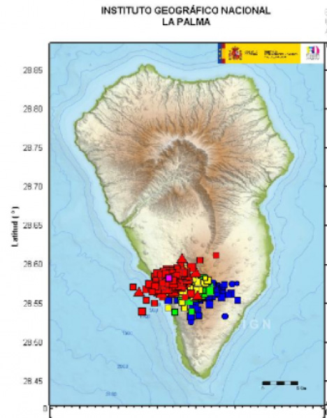
I looked at the La Palma earthquakes on https://www.emsc-csem.org/Earthquake/Map/gmap.php. If you zoom in on La Palma you'll see a strange pattern that appears to be too perfectly spaced apart and orderly to be random earthquakes. What makes it more interesting is that when I looked at other earthquake swarms around the planet they all seem randomly spaced. I guess they could have placed sensors in perfect patterns like this but just looks odd. I wouldn't all be surprised if they were intentionally trying to trigger a massive eruption. This would absolutely dwarf 9-11 in scale if it led to a huge tsunami. Just think, it all started in the Garden of Eden with one act of disobedience. Now we have wicked people eager to murder tens of millions of people at a time. :negative: Todd — I would agree the “pattern” does look to be more of the “man-made” variety. I have been following weather patterns, earthquakes, and planet anomalies for at least a decade or more and as Arthur put it — nothing surprises me regarding the evil present to “make a catastrophic” event occur. There are a variety of earthquakes that happen on a daily basis and at various levels within the earth layers. The tectonic plates shift as the earth rotates on it’s axis, some are felt and most are not. If you follow the fault lines (like in the Ring of fire) you then can grace it out to the path of shifting that will occur. Once a significant plate (there are several) shifts, it will cause a consistent shifting along the path (fault), going either north, or south; east or west. With Fracking, this is man-made and goes in multiple directions and in varied depths. Sometimes these man-made events due result in large Tsunami events along various coasts. Think of the experiments by the US government in the early centuries of shooting balloons and kites with dynamite into the skies around Texas to “make rain”. Caused a lot of noise, confusion, disruption of atmospheric pressures, but no rain :mdrmdr: What a craziness the prince of the world plays with our finite brains …. And we fall for it every time, just like the garden! B-) Here's why I think the whole thing could be a set up for a giant false flag event. listen from 1:10 - 3:40 on this video https://odysee.com/@RoystonPotter:b/update-on-lapalma-canary-islands:0 Start at 1:25 on this one And finally https://www.brighteon.com/4c2e65d3-a221-4f16-b4f5-032a6d9eb266 Truth! Below is a possible explanation. https://rense.com/general96/la-palma-quake-grid-pattern.php La Palma Quake Grid Pattern Explained Jeff Rense Thanks to Mike S for getting clarification regarding the earthquake grid pattern in the area of the Cumbre Vieja volcano. This does not in anyway dismiss the amazing numbers of quakes occurring, it only explains how they are represented on the EMSC map...in fact, there have already been over 275 quakes near and under the volcano just today. From m.c. - emsc-csem.org This is not unique to La Palma. It happens everywhere on our maps, whenever there is a huge zoom on a very small area. In La Palma, the artifact is more pronounced because of the very small size of the island. IGN, the authoritative source for seismic information in Spain, does not round the coordinates, and the seismicity does not look like a grid on their map: http://www.ign.es/web/ resources/sismologia/ tproximos/prox.html . We recommend consulting the local sources for tight seismicity like the one we are observing in La Palma. Instituto Geográfico Nacional, IGN Website: http://www.ign.es/ web/ign/portal Twitter: @IGN_Sismologia) Instituto Volcanológico de Canarias Website: https://www.involcan. org/ Twitter: @involcan) We are sorry for this misunderstanding and are glad of this opportunity to exchange with you and better explain our services. Best regards, The EMSC team Compare the two maps. Conclusion: square or triangular symbols have less distinct "rounding" errors. :mdrmdr: :mdrmdr: :stinkerbell: I've had this article (and others speaking of the same thing) tucked away in my computer for a while wondering if and when this might happen. Expert Warns of Volcano that Could Flatten the Entire U.S. East Coast In 1958, a huge cliff fell into the ocean at Letuya Bay. The resulting wall of water was so strong that it removed trees and soil 1,640 feet above sea level. The investigation of this phenomenon raised the question as to whether there were similar areas waiting to trigger a similar wave of destruction and sure enough a catastrophic disaster was found waiting to occur The Cumbre Vieja volcano on the island of La Palma is so unstable that scientists believe it could easily break away and collapse if it erupted. If that happened the 500 billion tons of rock plunging into the sea would create a splash more than 2,100 feet high and 25 feet across that would surge across the ocean toward America at 450 mph. A giant tsunami or massive seismic wave, reaching heights of more than 500 feet would be sent racing across the Atlantic at the speed of a passenger jet. Around nine hours later it would hit the Caribbean islands and the east coasts of Canada and the US. After traveling 4,000 miles the wave would be lower and wider but would still be 20 meters – 50 meters (66ft – 164ft) high. Stretching for many miles, it would home in on estuaries and harbors and sweep up to 20 miles inland, destroying everything in its path. Boston, New York, Washington DC and Miami would be virtually wiped off the map and tens of millions of people killed. Leading expert Professor Bill McGuire today said close monitoring might at best provide two weeks warning of the disaster but although the danger had been known about since the 1990s, no-one was keeping a proper watch on the mountain. 
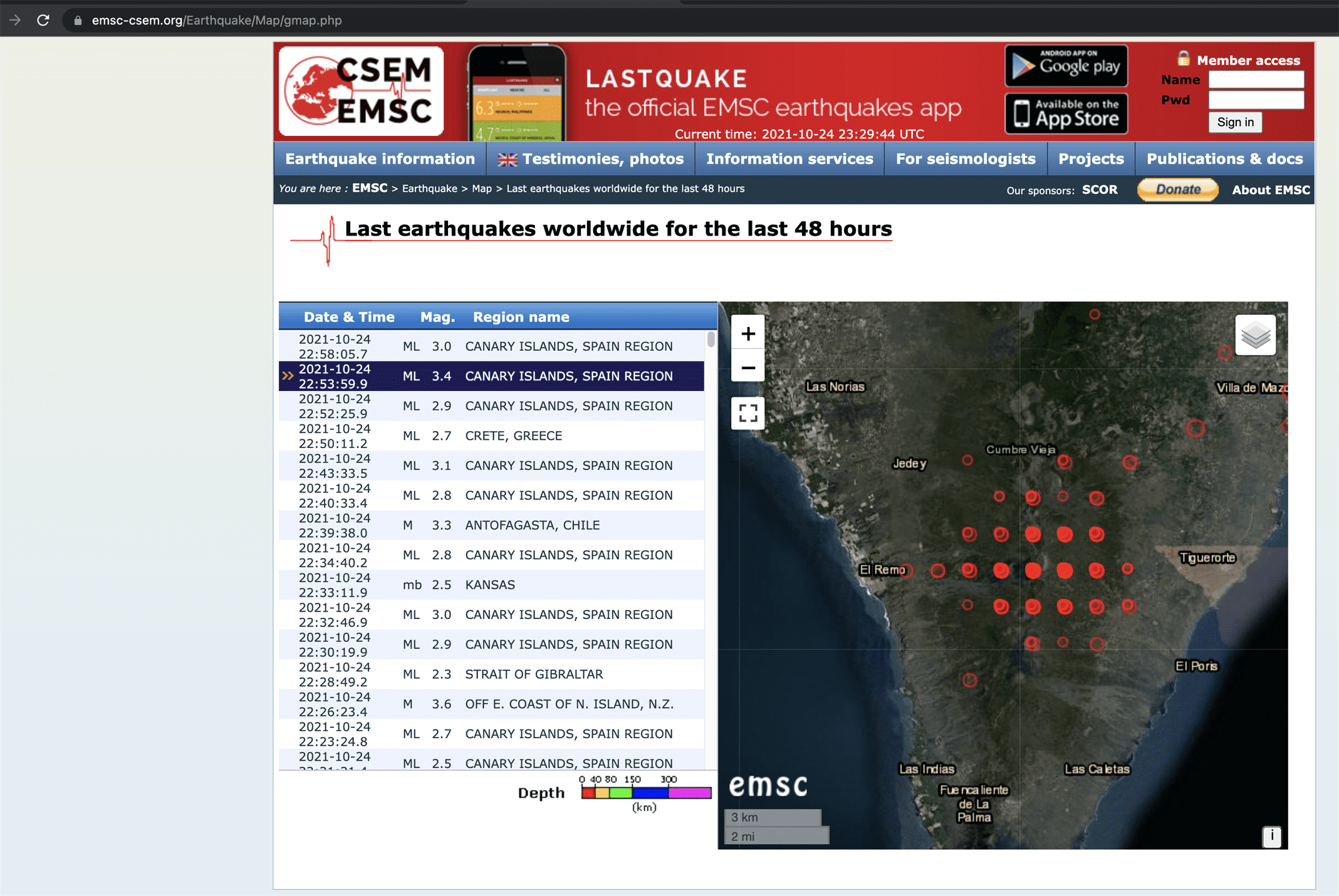


It Is Simply An Artifact Of Presentation
10-25-21
Sent: Monday, October 25, 2021 12:01 AM
To: Mike S
Subject: RE: Earthquake map question, grid pattern? Dear User, Thank you for writing to us about this matter. We have received many questions about the seismic activity in La Palma island displayed on our maps. The "grid" of earthquake locations is an artifact of how EMSC rounds longitude and latitude coordinates to two decimal points. We take this occasion to explain why the EMSC map displayed a grid pattern of earthquake locations in La Palma island. If you look at the longitude and latitude data provided by EMSC ( https://www.emsc-csem.org/#2 ) , you will see that there are two decimal points in each value, resulting in a less-granular, less-defined dataset. As a way of example, Google Earth uses 6 decimal points for the lon/lat couples. This allows for exponentially more granularity, which results in a higher-definition display.
In tight earthquake clusters like the ones occurring in La Palma, when you zoom way in, the 2 decimal point approximation creates an artifact and the earthquake locations are displayed like a grid.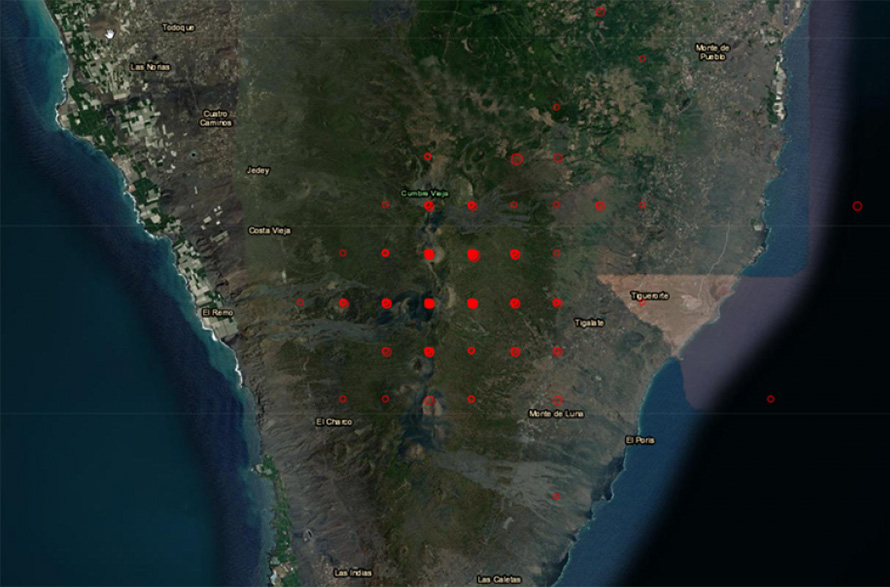


World leaders were today urged to wake up to the threat from a collapsing mountain which at any moment could unleash a massive tidal wave on the east coast of North America. A chunk of a volcano in the Canary Islands the size of the Isle of Man is on the brink of falling into the sea, a leading expert warned.
